Geography
Working reference only — no official map exists yet. The Mediterranean Sea serves as the "center of the world" and a real-world basis for comparison, not a literal template. Things will diverge as needed. For every named place in one list, see Gazetteer document.
Scale
The known continents run roughly 50% smaller than their real-world equivalents. This is a deliberate compression, not a precise ratio to hold writers/GMs to to in every case — but it's the working assumption for travel-time and distance sanity checks.
At 50% scale, Jerusalem to Gibraltar along the North African coast (real-world ~5,000 km) is roughly 2,500 km. Approximate travel times at that distance: - Dedicated courier/messenger (single rider, real pace, no relay stations): under two months - Caravan or ordinary overland traveler (roads, carts, standard rest and resupply): roughly a season — three to four months
Both figures are useful in-world texture — a courier can meaningfully outrun the news of himself by weeks, which matters for espionage, urgent treaties, and anyone trying to get ahead of a rumor.
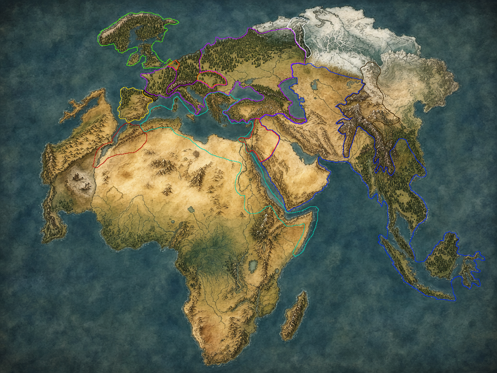
Draft 4 — another step toward the ideal, but still not final. The pale grey patch between Azlotl and Africa is the dried sea, and the two small ships on it are only there to show what it is. Its two volcanoes, Urzog and Burzug, aren't drawn yet, and would sit on the southern side, where Azlotl meets Africa. India has been removed, and Asia as a whole has shrunk significantly. One of the Indonesian islands is the far-eastern Elven vassal of Dar Ilm al-Zakir. The wintry zone now sits across the northeast, which is where the Northern Reaches live.
The Center — The Mediterranean Sea
The inland sea at the world's center is a living sea — full of water, sailed, fished, fought over. All Mediterranean islands remain Myrean Confederacy territory, and many of the Confederacy's greatest cities sit on the largest of them. Its first city, Myrea, is on the mainland, in Archaia (the Greece analog). Tallas, where the Long War's treaty was signed, sits on Eurystus (the Sicily analog), on the best harbor in the island's southeast, where Syracuse is in the real world, and the easiest to reach from across the sea. Syracuse still exists on Eurystus, but in the northeast, about where Messina is, on the strait closest to the Empire's Italy. It works from a lesser port, and it's much more of a naval city: it guarded the island against the Empire during the war. That's partly why the treaty was signed at Tallas: no delegation would sail into the Confederacy's strongest naval port to make peace. The Confederacy is a naval power built on that water, not an airship-dependent one — see The Myrean Confederacy document. Airships exist in Tir Hathar (Catfolk invention — see Catfolk document) and matter to later developments.
Regions
- Septentria — the Europe analog: the Caldrian Empire, Ssyrathis, the Dwarven ranges, and the Giants' northern holdings
- Tir Ynysael — the British Isles, Ireland, and Scandinavia, held by the Elves
- Tsagoi — the frozen north, held by the Ice-Trolls
- Khavaran — the Middle East through Central and Southeast Asia, and the Kuwaffri trench under the Red Sea
- Varsabad — the Indonesia analog, with the Elven vassal of Dar Ilm al-Zakir
- Theria — the Africa analog (the dinosaur continent), with its dinosaurs and the dead-magic Southern Cape
- Azlotl — the Mexico analog across the Lizard Sea (the dried sea): the Catfolk homeland, now goblin territory
Territory Map
The real-world analogs in this table are drafting shorthand. Where the outlined map disagrees, the map wins — Dar Ilm al-Zakir, for instance, reaches into Central Asia and mainland Southeast Asia on Draft 4, well beyond the table's row — and an artist's redraw will loosen the real-world resemblance further, for Myrea and Dar Ilm al-Zakir alike.
| Nation/People | Real-world analog |
|---|---|
| Caldrian Imperium | France, Italy, Slovenia, Croatia, Serbia, Bulgaria, Romania, Turkey, Albania |
| Myrean Confederacy | Egyptian/Libyan/Algerian coast only, Greece (Archaia), all Mediterranean islands (incl. Sardinia) |
| Monster Kingdom / Ssyrathis (Medusa Empire) | Iberian Peninsula (Spain & Portugal) |
| Dar Ilm al-Zakir | Arabian Peninsula, Iraq, Iran, Afghanistan, Pakistan |
| Giants | Morocco, Gibraltar, Israel, Jordan, Lebanon, Syria, Belgium, Hungary |
| Dwarves | Alps (Switzerland, Austria), Germany, Carpathians, Pyrenees, Urals, Himalayas |
| Elves | UK, Ireland, Scandinavia, a toe of the Netherlands; plus one Indonesian island, held as a Dar Ilm al-Zakir vassal |
Open / Undeveloped
- Any additional landmasses beyond the three established here
- What occupies the draft map's unassigned regions (India no longer exists on it, and Asia is much smaller): China east of the Himalayas (the Himalayas themselves are Himmelreich, the fifth Dwarven kingdom), Korea and Japan, and Siberia beyond the Northern Reaches
- Placement of the dragons' courts: the working three are placed (Xumaquixtzin's Feathered Court in Azlotl, Zakurgal's Lizard Court in Theria, and Tirhildis's Green Court in Septentria's Luxembourg analog); a fourth or fifth only if warranted