Geography
Working reference only — no official map exists yet. The Mediterranean Sea serves as the "center of the world" and a real-world basis for comparison, not a literal template. Things will diverge as needed.
Scale
The known continents run roughly 50% smaller than their real-world equivalents. This is a deliberate compression, not a precise ratio to hold writers/GMs to to in every case — but it's the working assumption for travel-time and distance sanity checks.
At 50% scale, Jerusalem to Gibraltar along the North African coast (real-world ~5,000 km) is roughly 2,500 km. Approximate travel times at that distance: - Dedicated courier/messenger (single rider, real pace, no relay stations): under two months - Caravan or ordinary overland traveler (roads, carts, standard rest and resupply): roughly a season — three to four months
Both figures are useful in-world texture — a courier can meaningfully outrun the news of himself by weeks, which matters for espionage, urgent treaties, and anyone trying to get ahead of a rumor.
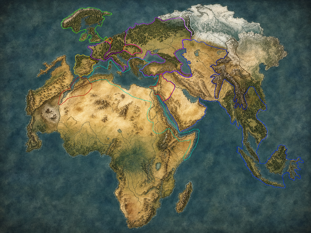
Draft 3 — another step toward the ideal, but still not final. The pale grey patch between Azlotl and Africa is the dried sea, and the two small ships on it are only there to show what it is. Its two volcanoes aren't drawn yet, and would sit on the southern side, where Azlotl meets Africa. India has been removed, and Asia as a whole has shrunk significantly. One of the Indonesian islands is the far-eastern Elven vassal of Dar Ilm al-Zakir. The wintry zone now sits across the northeast, which is where the Northern Reaches live.
The Center — The Mediterranean Sea
The inland sea at the world's center is a living sea — full of water, sailed, fished, fought over. All Mediterranean islands remain Myrean Confederacy territory, and many of the Confederacy's greatest cities sit on the largest of them. Its first city, Myrea, is on the mainland, in Archaia (the Greece analog). Tallas, where the Long War's treaty was signed, sits on Eurystus (the Sicily analog), on the best harbor in the island's southeast, where Syracuse is in the real world, and the easiest to reach from across the sea. Syracuse still exists on Eurystus, but in the northeast, about where Messina is, on the strait closest to the Empire's Italy. It works from a lesser port, and it's much more of a naval city: it guarded the island against the Empire during the war. That's partly why the treaty was signed at Tallas: no delegation would sail into the Confederacy's strongest naval port to make peace. The Confederacy is a naval power built on that water, not an airship-dependent one — see The Myrean Confederacy document. Airships exist in Tir Hathar (Catfolk invention — see Catfolk document) and matter to later developments.
Territory Map — Mediterranean-Analog Continent
The real-world analogs in this table are drafting shorthand. Where the outlined map disagrees, the map wins — Dar Ilm al-Zakir, for instance, reaches into Central Asia and mainland Southeast Asia on Draft 4, well beyond the table's row — and an artist's redraw will loosen the real-world resemblance further, for Myrea and Dar Ilm al-Zakir alike.
| Nation/People | Real-world analog |
|---|---|
| Caldrian Imperium | France, Italy, Slovenia, Croatia, Serbia, Bulgaria, Romania, Turkey, Albania |
| Myrean Confederacy | Egyptian/Libyan/Algerian coast only, Greece (Archaia), all Mediterranean islands (incl. Sardinia) |
| Monster Kingdom / Ssyrathis (Medusa Empire) | Iberian Peninsula (Spain & Portugal) |
| Dar Ilm al-Zakir | Arabian Peninsula, Iraq, Iran, Afghanistan, Pakistan |
| Giants | Morocco, Gibraltar, Israel, Jordan, Lebanon, Syria, Belgium, Hungary |
| Dwarves | Alps (Switzerland, Austria), Germany, Carpathians, Pyrenees, Urals |
| Elves | UK, Ireland, Netherlands; plus one Indonesian island, held as a Dar Ilm al-Zakir vassal |
Hungary is settled Giant territory (Zumakim) — not contested. The Giants took it very early in the Long War, around the same time as the sea-draining and the Catfolk Diaspora (see below and Giant Kingdoms document). The Imperium still nurses an old, mostly symbolic claim to it — the kind of grievance a nation keeps alive in schoolbooks rather than at the negotiating table — but there's no live dispute, no secret treaty, and nothing to hide.
Borders Worth Noting
- Monster Kingdom ↔ Dwarves: the Pyrenees, held by Dwarves, sit directly between the Imperium (France) and the Monster Kingdom (Iberia) — a chokepoint under dwarven control.
- Monster Kingdom ↔ Giants: Gibraltar, known in Tir Hathar as the Pillars of Heracles. The single most tense border location on the map — two non-human powers in direct contact, neither of which most human nations fully trust.
- Monster Kingdom ↔ Confederacy: unofficial — the Iberian Mediterranean shore facing Confederacy island holdings. The Confederacy's outer islands are its most exposed, least-defensible territory.
- Dwarves are not one kingdom but a loose collection of mountain kingdoms sharing culture and trade, spread across every major range on the continent (Alps, Carpathians, Pyrenees, Urals, Himalayas) — plus a lost foothold on the farside landmass; see below.
- Dar Ilm al-Zakir is the largest single territory on the map by a wide margin — coherence maintained through the Majlis structure and trade networks rather than military occupation.
- Elves are geographically the most isolated — separated from the continent by the Channel, with only a toe of territory in the Netherlands where the occasional Thorn slips through.
The Northern Reaches
Northeast of the Imperium and the Dwarven ranges sits an abbreviated Poland/Russia analog — compressed well past the usual 50% scale, but still sizable enough to be territory every bordering nation eyes and none has taken. The Ice-Trolls make up its "teeth" — one regenerating species, sexually dimorphic into nomadic, mammoth-riding males ("Yeti") and settled, spider-farming females ("Hags") — a biology-beats-army deterrent in the same category as the dinosaur continent's dinosaurs, not a political or military one, and not malice either: they're naturalists defending the grazing land their whole economy depends on. See The Northern Reaches and Peoples_Unconquered documents.
Draft-map note: on the world map, the wintry zone that sits up in the polar north gets dragged south, out of the Arctic fringe and into the great forest belt in the east. The Reaches are best pictured as that eastern woodland — taiga, tundra-steppe, and ice at its harshest edges — rather than as a strip of polar coast.
The Far-Eastern Elven Vassal (an Indonesian Island)
One Indonesian island is a second Elven foothold, held as a vassal of Dar Ilm al-Zakir rather than as part of Silbriesti. That gives the Elves the east and west split the setting has been leaning toward, with a cool, isolationist Taniere on one edge of the map and a tropical, maritime island on the other. It also sets the Scholar Nation up as an Indian Ocean power whose reach is measured in sea lanes and tribute rather than occupied territory, which is the same coherence-through-networks model it already runs at home. The original vassal-state framing still holds: interested in succeeding but not desperate, since Dar Ilm isn't a pushy patron. This replaces the earlier idea of a Korea-, China-, or Japan-inspired island.
Open: which island it is (deliberately left for much later); its name; its culture beyond "tropical, maritime, Elven"; whether it answers to Silbriesti at all or only to Dar Ilm; how the two Elven peoples regard each other; how it fared in the Long War.
The Dinosaur Continent
African Analog
Same landmass the Confederacy and Giants already hold partial territory on:
- Myrean Confederacy — coast only (Egyptian/Libyan/Algerian shore, as above)
- Giants — Morocco/Gibraltar corner, as above
- Lizardfolk — hold the interior, unconquered. Dinosaurs as the continent's apex predators are the reason why: no army, human or otherwise, has taken the interior at acceptable cost. This makes Lizardfolk sovereignty a fact of geography and biology rather than an accident of nobody bothering.
- Kobolds — subordinate to Lizardfolk within this same territory
Dinosaurs run continent-wide, not confined to one region — but at natural-apex-predator density, not saturation. Think lion-equivalent numbers for something like a T-Rex: rare enough that a sighting is a genuine event, not a random encounter roll, and concentrated near water sources the way real apex predators cluster, rather than evenly spread. This keeps "dinosaurs everywhere" from meaning "a dinosaur every ten miles."
The continent's shape is kept as a real-world Africa analog, shrunk at the same ~50% scale as everything else — which means its climate bands hold roughly the same relationship to latitude they do now. That implies a Sahara-equivalent arid, sparsely inhabited band across the north, separate from and in addition to the dinosaur-driven wildness of the interior further south. That empty north is a second, independent reason Confederacy and Giant territory clusters where it does (coast and the water-adjacent Gibraltar corner) — not just avoiding dinosaurs, but avoiding true desert as well.
There is a Dragon court in Africa. There are also a few attempts (some failed) at colonies in Africa, but they remain very small walled territories.
The Southern Cape — a Dead-Magic Zone
At the continent's actual southern tip (the South Africa analog — well south of the Lizardfolk interior and unrelated to the Azlotl crossing far up the west coast) magic simply doesn't function. Confirmed as a real feature of the world, not yet developed beyond that: exact size, cause (planar-scar damage, something older, something else entirely), and what it means for anyone or anything living there or passing through are all still open. Flagged here so it isn't lost before there's time to think it through.
Open: size and precise boundary of the dead zone; cause; whether anyone lives there and how; what "no magic functions" means for Sigil-bearers, regenerating creatures, or anything else whose nature is arguably magical rather than just magically-assisted.
The Kuwaffri Trench (Red Sea-Analog)
Where the Red Sea would sit — between Dar Ilm al-Zakir and the dinosaur continent's Giant (Morocco/Israel) and Confederacy (Egyptian coast) shores — the seabed hides a genuine drowned rift, deep enough that the bottom holds an air-filled cavern nobody has ever found. This is the Kuwaffri homeland (see Kuwaffri document for the full race write-up). Distance was never the reason nobody's found them; depth is. The Red Sea reads as the strongest fit for this precisely because it's a real-world tectonic rift valley — an honest geological reason for a trench to exist here rather than an ordinary continental shelf — and because it sits close to three civilizations' home waters without belonging to any of them, which keeps a hidden people plausible without needing true open-ocean isolation. The Persian Gulf and Arabian Sea were both considered and set aside: the Gulf is realistically too shallow for "swim down, not out," and the Arabian Sea remains a fine deep-ocean fallback if ever needed elsewhere.
Open: exact size and depth of the trench and the home cavern; whether any surface nation has ever picked up rumor of something living down there.
Azlotl and the Dried Sea
(Catfolk Homeland, Now Goblin Territory)
Off the dinosaur continent's west coast — roughly the Western Sahara and Mauritania stretch — sits a second, separate landmass, roughly the size and shape of a Mexico analog, called Azlotl (AHZ-lotl), mostly jungle. It sits close enough to Africa that the water between the two reads as an enclosed sea, not open ocean, its character partly inspired by the Amazon, the Yucatan, and the Caribbean — winding delta channels and island chains, now all salt flats, dry channels, and exposed reefs instead of open water. That enclosed body is the world's actual dried sea.
The connection to Africa: Azlotl and the dinosaur continent actually touch at a southern point — the southern side of the dried sea, where Azlotl's southern reaches meet Africa's west coast — forming the seabed's enclosed basin. That connection is marked by two large volcanoes (unnamed) flanking a narrow crossing, which keeps ordinary travel and cultural crossover between the two landmasses down to nearly nothing despite the physical link.
Catfolk homeland: Before the sea dried, both shores — the dinosaur continent's coast and Azlotl itself — were Catfolk ancestral territory, and Catfolk civilization there was fully Aztec/Incan-coded and thoroughly maritime: cities on both coasts, a fleet that used the sea as a highway rather than a barrier. Catfolk ruins are scattered across all of Azlotl today — the physical remainder of a civilization that no longer holds the land. See Catfolk document.
The draining: Very early in the Long War, the Giants dried the sea, with the Caldrian Imperium lending a hand. The mechanism was rivers internal to Azlotl itself: the Giants redirected the landmass's major rivers to empty into the open ocean on Azlotl's far side instead of into the enclosed sea, and the basin dried out from there. This is no longer treated as a tightly held secret — it's known, or safely assumed, well beyond whatever small circle used to guard it. It was an act of war: draining the sea broke Catfolk civilization and took the Catfolk out of the Long War entirely, scattering them into diaspora (the Catfolk Diaspora) rather than defeating them in the field. See Catfolk and Giant Kingdoms documents.
Dwarven ruins: A mountain range on Azlotl's far side — opposite the volcano crossing to Africa — was once a Dwarven holding, a sixth kingdom alongside the five on the main continent. The Dwarves were driven out by goblins after the Catfolk Diaspora and never reclaimed it. Old Dwarven ruins remain in those mountains.
Goblin takeover: With the Catfolk gone, goblins — previously a much smaller presence — spread to fill the vacuum across Azlotl, including eventually pushing the Dwarves out of their mountain foothold. The Giants more or less expected this, if they didn't outright intend it. See Goblins document.
Gold, and a dragon: Azlotl holds more than its fair share of the world's gold. That wealth is a real part of why Azlotl has its own dragon — the Feathered Serpent, ruling a Demesne built on goblin labor, gold, and sheer charisma, with a Regent and Seneschal both drawn from Dwarven and Catfolk remnants who never left. See Dragons document.
Open: exact placement/scale of Azlotl relative to the dinosaur continent and the rest of the map; names for the dried sea, the two volcanoes, and the lost Dwarven mountain kingdom; how "known" the Giants/Imperium role in the draining actually is on a nation-by-nation basis.
Open / Undeveloped
- Shape and extent of the dinosaur continent beyond the coastal claims above
- Exact placement and scale of Azlotl and its dried sea
- Any additional landmasses beyond the three established here
- What occupies the draft map's unassigned regions (India no longer exists on it, and Asia is much smaller): China east of the Himalayas (the Himalayas themselves are Himmelreich, the fifth Dwarven kingdom), mainland Southeast Asia, Korea and Japan, Scandinavia, Central Asia, and Siberia beyond the Northern Reaches
- Placement of the Dragon [Courts/Wyrmrests/Demesnes — naming TBD] — likely spread across multiple landmasses given their small number (3, possibly 5) and reclusive nature